


| The World Factbook | ||
|
|
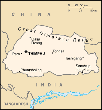
Bhutan |
|
|
| Introduction | Bhutan |
|
Background:
|
In 1865, Britain and Bhutan signed the Treaty of Sinchulu, under which Bhutan would receive an annual subsidy in exchange for ceding some border land to British India. Under British influence, a monarchy was set up in 1907; three years later, a treaty was signed whereby the British agreed not to interfere in Bhutanese internal affairs and Bhutan allowed Britain to direct its foreign affairs. This role was assumed by independent India after 1947. Two years later, a formal Indo-Bhutanese accord returned the areas of Bhutan annexed by the British, formalized the annual subsidies the country received, and defined India's responsibilities in defense and foreign relations. A refugee issue of some 100,000 Bhutanese in Nepal remains unresolved; 90% of the refugees are housed in seven United Nations Office of the High Commissioner for Refugees (UNHCR) camps. In March 2005, King Jigme Singye WANGCHUCK unveiled the government's draft constitution - which would introduce major democratic reforms - and pledged to hold a national referendum for its approval. A referendum date has yet to be named, but should occur in 2008. In December 2006, the King abdicated the throne to his son, Jigme Khesar Namgyel WANGCHUCK, in order to give him experience as head of state before the democratic transition. |
| Geography | Bhutan |
|
Location:
|
Southern Asia, between China and India |
|
Geographic coordinates:
|
27 30 N, 90 30 E |
|
Map references:
|
Asia |
|
Area:
|
total: 47,000 sq km
land: 47,000 sq km water: 0 sq km |
|
Area - comparative:
|
about half the size of Indiana |
|
Land boundaries:
|
total: 1,075 km
border countries: China 470 km, India 605 km |
|
Coastline:
|
0 km (landlocked) |
|
Maritime claims:
|
none (landlocked) |
|
Climate:
|
varies; tropical in southern plains; cool winters and hot summers in central valleys; severe winters and cool summers in Himalayas |
|
Terrain:
|
mostly mountainous with some fertile valleys and savanna |
|
Elevation extremes:
|
lowest point: Drangme Chhu 97 m
highest point: Kula Kangri 7,553 m |
|
Natural resources:
|
timber, hydropower, gypsum, calcium carbonate |
|
Land use:
|
arable land: 2.3%
permanent crops: 0.43% other: 97.27% (2005) |
|
Irrigated land:
|
400 sq km (2003) |
|
Natural hazards:
|
violent storms from the Himalayas are the source of the country's name, which translates as Land of the Thunder Dragon; frequent landslides during the rainy season |
|
Environment - current issues:
|
soil erosion; limited access to potable water |
|
Environment - international agreements:
|
party to: Biodiversity, Climate Change, Climate Change-Kyoto Protocol, Desertification, Endangered Species, Hazardous Wastes
signed, but not ratified: Law of the Sea |
|
Geography - note:
|
landlocked; strategic location between China and India; controls several key Himalayan mountain passes |
| People | Bhutan |
|
Population:
|
2,279,723
note: other estimates range as low as 810,000 (July 2006 est.) |
|
Age structure:
|
0-14 years: 38.9% (male 458,801/female 426,947)
15-64 years: 57.1% (male 671,057/female 631,078) 65 years and over: 4% (male 46,217/female 45,623) (2006 est.) |
|
Median age:
|
total: 20.4 years
male: 20.2 years female: 20.6 years (2006 est.) |
|
Population growth rate:
|
2.1% (2006 est.) |
|
Birth rate:
|
33.65 births/1,000 population (2006 est.) |
|
Death rate:
|
12.7 deaths/1,000 population (2006 est.) |
|
Net migration rate:
|
0 migrant(s)/1,000 population (2006 est.) |
|
Sex ratio:
|
at birth: 1.05 male(s)/female
under 15 years: 1.07 male(s)/female 15-64 years: 1.06 male(s)/female 65 years and over: 1.01 male(s)/female total population: 1.07 male(s)/female (2006 est.) |
|
Infant mortality rate:
|
total: 98.41 deaths/1,000 live births
male: 96.14 deaths/1,000 live births female: 100.79 deaths/1,000 live births (2006 est.) |
|
Life expectancy at birth:
|
total population: 54.78 years
male: 55.02 years female: 54.53 years (2006 est.) |
|
Total fertility rate:
|
4.74 children born/woman (2006 est.) |
|
HIV/AIDS - adult prevalence rate:
|
less than 0.1% (2001 est.) |
|
HIV/AIDS - people living with HIV/AIDS:
|
less than 100 (1999 est.) |
|
HIV/AIDS - deaths:
|
NA |
|
Nationality:
|
noun: Bhutanese (singular and plural)
adjective: Bhutanese |
|
Ethnic groups:
|
Bhote 50%, ethnic Nepalese 35% (includes Lhotsampas - one of several Nepalese ethnic groups), indigenous or migrant tribes 15% |
|
Religions:
|
Lamaistic Buddhist 75%, Indian- and Nepalese-influenced Hinduism 25% |
|
Languages:
|
Dzongkha (official), Bhotes speak various Tibetan dialects, Nepalese speak various Nepalese dialects |
|
Literacy:
|
definition: age 15 and over can read and write
total population: 47% male: 60% female: 34% (2003 est.) |
| Government | Bhutan |
|
Country name:
|
conventional long form: Kingdom of Bhutan
conventional short form: Bhutan local long form: Druk Gyalkhap local short form: Druk Yul |
|
Government type:
|
absolute monarchy; special treaty relationship with India; note - transition to a constitutional monarchy is expected in 2008 |
|
Capital:
|
name: Thimphu
geographic coordinates: 27 28 N, 89 39 E time difference: UTC+6 (11 hours ahead of Washington, DC during Standard Time) |
|
Administrative divisions:
|
18 districts (dzongkhag, singular and plural); Bumthang, Chhukha, Chirang, Dagana, Geylegphug, Ha, Lhuntshi, Mongar, Paro, Pemagatsel, Punakha, Samchi, Samdrup Jongkhar, Shemgang, Tashigang, Thimphu, Tongsa, Wangdi Phodrang
note: there may be two new districts named Gasa and Yangtse |
|
Independence:
|
8 August 1949 (from India) |
|
National holiday:
|
National Day (Ugyen WANGCHUCK became first hereditary king), 17 December (1907) |
|
Constitution:
|
none; note - a draft constitution was unveiled in March 2005 and is expected to be adopted following the election of a new National Assembly in 2008 |
|
Legal system:
|
based on Indian law and English common law; has not accepted compulsory ICJ jurisdiction |
|
Suffrage:
|
each family has one vote in village-level elections |
|
Executive branch:
|
chief of state: King Jigme Khesar Namgyel WANGCHUCK (since 14 December 2006); note - King Jigme Singye WANGCHUCK abdicated the throne on 14 December 2006 and his son immediately succeeded him
head of government: Prime Minister Khandu WANGCHUK (since 7 September 2006) cabinet: Council of Ministers (Lhengye Shungtsog) nominated by the monarch, approved by the National Assembly; members serve fixed, five-year terms; note - there is also a Royal Advisory Council (Lodoi Tsokde), members nominated by the monarch elections: none; the monarch is hereditary, but democratic reforms in July 1998 grant the National Assembly authority to remove the monarch with two-thirds vote; election of a new National Assembly is expected in 2008 |
|
Legislative branch:
|
unicameral National Assembly or Tshogdu (150 seats; 105 elected from village constituencies, 10 represent religious bodies, and 35 are designated by the monarch to represent government and other secular interests; members serve three-year terms)
elections: local elections last held August 2005 (next to be held in 2008) election results: NA |
|
Judicial branch:
|
Supreme Court of Appeal (the monarch); High Court (judges appointed by the monarch) |
|
Political parties and leaders:
|
no legal parties |
|
Political pressure groups and leaders:
|
Buddhist clergy; ethnic Nepalese organizations leading militant antigovernment campaign; Indian merchant community; United Front for Democracy (exiled) |
|
International organization participation:
|
AsDB, BIMSTEC, CP, FAO, G-77, IBRD, ICAO, IDA, IFAD, IFC, IMF, Interpol, IOC, IOM (observer), ISO (correspondent), ITU, NAM, OPCW, SAARC, SACEP, UN, UNCTAD, UNESCO, UNIDO, UNWTO, UPU, WCO, WHO, WIPO, WMO, WTO (observer) |
|
Diplomatic representation in the US:
|
none; note - the Permanent Mission to the UN for Bhutan has consular jurisdiction in the US; address: 2 United Nations Plaza, 27th Floor, New York, NY 10017; telephone [1] (212) 826-1919; FAX [1] (212) 826-2998
consulate(s) general: New York |
|
Diplomatic representation from the US:
|
the US and Bhutan have no formal diplomatic relations, although informal contact is maintained between the Bhutanese and US Embassy in New Delhi (India) |
|
Flag description:
|
divided diagonally from the lower hoist side corner; the upper triangle is yellow and the lower triangle is orange; centered along the dividing line is a large black and white dragon facing away from the hoist side |
| Economy | Bhutan |
|
Economy - overview:
|
The economy, one of the world's smallest and least developed, is based on agriculture and forestry, which provide the main livelihood for more than 80% of the population. Agriculture consists largely of subsistence farming and animal husbandry. Rugged mountains dominate the terrain and make the building of roads and other infrastructure difficult and expensive. The economy is closely aligned with India's through strong trade and monetary links and dependence on India's financial assistance. The industrial sector is technologically backward, with most production of the cottage industry type. Most development projects, such as road construction, rely on Indian migrant labor. Bhutan's hydropower potential and its attraction for tourists are key resources. Model education, social, and environment programs are underway with support from multilateral development organizations. Each economic program takes into account the government's desire to protect the country's environment and cultural traditions. For example, the government, in its cautious expansion of the tourist sector, encourages visits by upscale, environmentally conscientious tourists. Detailed controls and uncertain policies in areas such as industrial licensing, trade, labor, and finance continue to hamper foreign investment. |
|
GDP (purchasing power parity):
|
$2.9 billion (2003 est.) |
|
GDP (official exchange rate):
|
$840.5 million (2005 est.) |
|
GDP - real growth rate:
|
8.8% (2005 est.) |
|
GDP - per capita (PPP):
|
$1,400 (2003 est.) |
|
GDP - composition by sector:
|
agriculture: 24.7%
industry: 37.2% services: 38.1% (2005) |
|
Labor force:
|
NA
note: major shortage of skilled labor |
|
Labor force - by occupation:
|
agriculture: 63%
industry: 6% services: 31% (2004 est.) |
|
Unemployment rate:
|
2.5% (2004) |
|
Population below poverty line:
|
31.7% (2003) |
|
Household income or consumption by percentage share:
|
lowest 10%: NA%
highest 10%: NA% |
|
Inflation rate (consumer prices):
|
5.5% (2005 est.) |
|
Budget:
|
revenues: $272 million
expenditures: $350 million; including capital expenditures of $NA note: the government of India finances nearly three-fifths of Bhutan's budget expenditures (2005) |
|
Public debt:
|
81.4% of GDP (2004) |
|
Agriculture - products:
|
rice, corn, root crops, citrus, foodgrains; dairy products, eggs |
|
Industries:
|
cement, wood products, processed fruits, alcoholic beverages, calcium carbide, tourism |
|
Industrial production growth rate:
|
9.3% (1996 est.) |
|
Electricity - production:
|
2.05 billion kWh (2004) |
|
Electricity - production by source:
|
fossil fuel: 0.1%
hydro: 99.9% nuclear: 0% other: 0% (2001) |
|
Electricity - consumption:
|
526.5 million kWh (2004) |
|
Electricity - exports:
|
1.4 billion kWh (2004) |
|
Electricity - imports:
|
20 million kWh (2004) |
|
Oil - production:
|
0 bbl/day (2004) |
|
Oil - consumption:
|
1,160 bbl/day (2004 est.) |
|
Oil - exports:
|
NA bbl/day |
|
Oil - imports:
|
NA bbl/day |
|
Natural gas - production:
|
0 cu m (2004 est.) |
|
Natural gas - consumption:
|
0 cu m (2004 est.) |
|
Natural gas - proved reserves:
|
0 cu m (1 January 2005 est.) |
|
Exports:
|
$186 million f.o.b. (2005) |
|
Exports - commodities:
|
electricity (to India), cardamom, gypsum, timber, handicrafts, cement, fruit, precious stones, spices |
|
Exports - partners:
|
India 69.3%, Japan 9.1%, Germany 3.7% (2005) |
|
Imports:
|
$410 million c.i.f. (2005) |
|
Imports - commodities:
|
fuel and lubricants, grain, aircraft, machinery and parts, vehicles, fabrics, rice |
|
Imports - partners:
|
India 75.3%, Hong Kong 16.1%, Mexico 4.9% (2005) |
|
Debt - external:
|
$593 million (2004) |
|
Economic aid - recipient:
|
$78 million substantial aid from India and other nations (2004) |
|
Currency (code):
|
ngultrum (BTN); Indian rupee (INR) |
|
Currency code:
|
BTN; INR |
|
Exchange rates:
|
ngultrum per US dollar - 45.279 (2006), 44.101 (2005), 45.317 (2004), 46.583 (2003), 48.61 (2002)
note: the ngultrum is pegged to the Indian rupee |
|
Fiscal year:
|
1 July - 30 June |
| Communications | Bhutan |
|
Telephones - main lines in use:
|
32,700 (2005) |
|
Telephones - mobile cellular:
|
37,800 (2005) |
|
Telephone system:
|
general assessment: telecommunications facilities are poor
domestic: very low teledensity; domestic service is very poor especially in rural areas; wireless service available since 2003 international: country code - 975; international telephone and telegraph service via landline and microwave relay through India; satellite earth station - 1 (2005) |
|
Radio broadcast stations:
|
AM 0, FM 9, shortwave 1 (2006) |
|
Radios:
|
37,000 (1997) |
|
Television broadcast stations:
|
1 (2006) |
|
Televisions:
|
11,000 (1997) |
|
Internet country code:
|
.bt |
|
Internet hosts:
|
7,567 (2006) |
|
Internet Service Providers (ISPs):
|
NA |
|
Internet users:
|
25,000 (2005) |
| Transportation | Bhutan |
|
Airports:
|
2 (2006) |
|
Airports - with paved runways:
|
total: 1
1,524 to 2,437 m: 1 (2006) |
|
Airports - with unpaved runways:
|
total: 1
914 to 1,523 m: 1 (2006) |
|
Roadways:
|
total: 8,050 km
paved: 4,991 km unpaved: 3,059 km (2003) |
| Military | Bhutan |
|
Military branches:
|
Royal Bhutan Army: Royal Bodyguard, Royal Bhutan Police (2005) |
|
Military service age and obligation:
|
18 years of age for voluntary military service; no conscription (2001) |
|
Manpower available for military service:
|
males age 18-49: 483,860
females age 18-49: 453,683 (2005 est.) |
|
Manpower fit for military service:
|
males age 18-49: 314,975
females age 18-49: 296,833 (2005 est.) |
|
Manpower reaching military service age annually:
|
males age 18-49: 23,939
females age 18-49: 21,979 (2005 est.) |
|
Military expenditures - dollar figure:
|
$8.29 million (2005 est.) |
|
Military expenditures - percent of GDP:
|
1% (2005 est.) |
| Transnational Issues | Bhutan |
|
Disputes - international:
|
over 106,000 Bhutanese Lhotshampas (Hindus) have been confined in seven UN Office of the High Commissioner for Refugees camps since 1990; Bhutan cooperates with India to expel Indian Nagaland separatists; lacking any treaty describing the boundary, Bhutan and China continue negotiations to establish a boundary alignment to resolve substantial cartographic discrepancies, the largest of which lies in Bhutan's northwest |
|
This page was last updated on 15 March, 2007 |